
Make a donation
Gear up for your next adventure:
As an Amazon Associate, this site earns from qualifying purchases at no extra cost to you.
Cartago Province topographic map
Click on the map to display elevation.
Make a donation
Gear up for your next adventure:
As an Amazon Associate, this site earns from qualifying purchases at no extra cost to you.
About this map
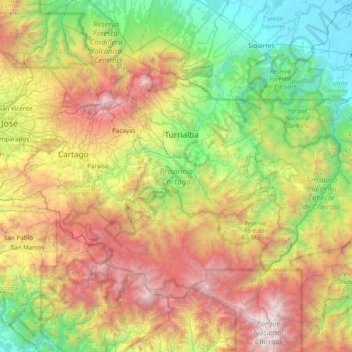
Name: Cartago Province topographic map, elevation, terrain.
Location: Cartago Province, Costa Rica (9.48431 -84.08812 10.14731 -83.31560)
Average elevation: 4,508 ft
Minimum elevation: 7 ft
Maximum elevation: 12,421 ft
Make a donation
Gear up for your next adventure:
As an Amazon Associate, this site earns from qualifying purchases at no extra cost to you.
Other topographic maps
Click on a map to view its topography, its elevation and its terrain.
Arenal Volcano
Costa Rica > Cantón San Carlos > La Fortuna
Arenal has several eruptive vents. Chato is a dormant stratovolcanic cone. It is believed that Chato first erupted 38,000 years ago during the Pleistocene period and last erupted about 3,500 years ago. Chatito is a lava dome with an elevation of 1,100 metres (3,609 ft). Espina is another lava dome.
Average elevation: 3,327 ft
Make a donation
Gear up for your next adventure:
As an Amazon Associate, this site earns from qualifying purchases at no extra cost to you.
Playa Avellanas
Costa Rica > Cantón Santa Cruz > Veintisiete de Abril > Tamarindo
Average elevation: 26 ft
Platanillo
Costa Rica > San Jose Province > Cantón Pérez Zeledón > Barú > Platanillo
Average elevation: 1,237 ft