Geolocate

Willow topographic map

Click on the map to display elevation.

About this map

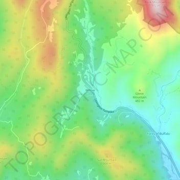
Name: Willow topographic map, elevation, terrain.

Location: Willow, Amherst County, Virginia, United States (37.67041 -79.26114 37.71041 -79.22114)

Average elevation: 1,490 ft

Minimum elevation: 873 ft

Maximum elevation: 2,543 ft

Amherst County trails, hiking, mountain biking, running and outdoor activities

Gear up for your next adventure:

🎒Hydration Pack - Hands‑free water reservoir for long hikes
🪶Paracord Bracelet - Survival bracelet with built‑in tools
🛠️Outdoor Gear Repair Kit - Essential tools to fix gear on the trail
🍳Camping Cook Set - Complete cookware for outdoor meals
🌎3D Topographic Globes - Raised relief globes for a tactile understanding of geography

As an Amazon Associate, this site earns from qualifying purchases at no extra cost to you.