
Make a donation
Gear up for your next adventure:
As an Amazon Associate, this site earns from qualifying purchases at no extra cost to you.
Mögglingen topographic map
Click on the map to display elevation.
Make a donation
Gear up for your next adventure:
As an Amazon Associate, this site earns from qualifying purchases at no extra cost to you.
Mögglingen
Mögglingen liegt in 398 bis 475 Meter Höhe im Vorland der östlichen Schwäbischen Alb im oberen Tal der Rems zwischen der Kreisstadt Aalen (11 km im Osten) und der Stadt Schwäbisch Gmünd (13 km im Westen).
Make a donation
Gear up for your next adventure:
As an Amazon Associate, this site earns from qualifying purchases at no extra cost to you.
About this map
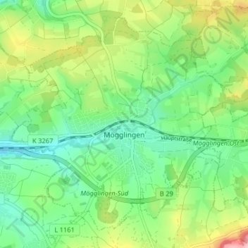
Name: Mögglingen topographic map, elevation, terrain.
Average elevation: 1,460 ft
Minimum elevation: 1,280 ft
Maximum elevation: 1,808 ft
Make a donation
Gear up for your next adventure:
As an Amazon Associate, this site earns from qualifying purchases at no extra cost to you.
Other topographic maps
Click on a map to view its topography, its elevation and its terrain.
Aalen
Deutschland > Baden-Württemberg > Ostalbkreis > Aalen > Aalen
Da sich das Stadtgebiet Aalens über das Albvorland, die Voralb, den Albuch und über das Härtsfeld erstreckt und dabei insgesamt 355 Höhenmeter Unterschied zwischen tiefstem und höchstem Punkt überwindet, ist das Klima von Stadtbezirk zu Stadtbezirk verschieden.
Average elevation: 1,739 ft