Geolocate

Cinisi topographic map

Click on the map to display elevation.

About this map

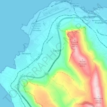
Name: Cinisi topographic map, elevation, terrain.

Location: Cinisi, Palermo, Sicily, 90045, Italy (38.11378 13.07686 38.19181 13.14995)

Average elevation: 725 ft

Minimum elevation: 0 ft

Maximum elevation: 3,192 ft

Other topographic maps

Click on a map to view its topography, its elevation and its terrain.

Sorgente di Montescuro

Italy > Sicily > Palermo > Prizzi

Average elevation: 2,726 ft

Bellacera

Italy > Sicily > Palermo > Santa Flavia

Average elevation: 531 ft

Finale

Italy > Sicily > Palermo

Average elevation: 276 ft

Santa Lucia

Italy > Sicily > Palermo > Cefalù

Average elevation: 167 ft

San Carlo

Italy > Sicily > Palermo > Chiusa Sclafani

Average elevation: 955 ft

Gear up for your next adventure:

🌡️Portable Weather Meter - Track weather conditions on the trail
🧯Emergency Survival Kit - All‑in‑one survival essentials for the backcountry
🪶Camp Gear Gift Set - Perfect gift bundle for outdoor fans
🔭Compact Binoculars - HD vision for scouting terrain and identifying distant landmarks
🌲Outdoor Survival Books - Best books on survival skills

As an Amazon Associate, this site earns from qualifying purchases at no extra cost to you.