
Make a donation
Gear up for your next adventure:
As an Amazon Associate, this site earns from qualifying purchases at no extra cost to you.
Puerta Dorada topographic map
Click on the map to display elevation.
Make a donation
Gear up for your next adventure:
As an Amazon Associate, this site earns from qualifying purchases at no extra cost to you.
About this map
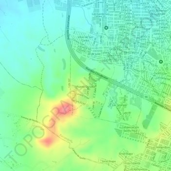
Name: Puerta Dorada topographic map, elevation, terrain.
Location: Puerta Dorada, Barranquilla, Atlántico, Colombia (10.92180 -74.83391 10.93227 -74.82753)
Average elevation: 207 ft
Minimum elevation: 102 ft
Maximum elevation: 410 ft
Make a donation
Gear up for your next adventure:
As an Amazon Associate, this site earns from qualifying purchases at no extra cost to you.
Other topographic maps
Click on a map to view its topography, its elevation and its terrain.
Barranquilla
Colombia > Atlántico > Barranquilla > Barranquilla
El sistema de alcantarillado de la ciudad es subterráneo y único. Las redes de drenaje conducen las aguas residuales en forma paralela a la red de agua potable hacia los cuerpos de agua sin recibir ningún tipo de tratamiento. De acuerdo con la topografía de Barranquilla, el alcantarillado de la ciudad se…
Average elevation: 89 ft
Parque San Pio
Colombia > Atlántico > Barranquilla > Perímetro Urbano Barranquilla
Average elevation: 167 ft
Parque Santander
Colombia > Atlántico > Barranquilla > Perímetro Urbano Barranquilla
Average elevation: 128 ft
Bulevar de Simón Bolívar
Colombia > Atlántico > Barranquilla > Perímetro Urbano Barranquilla
Average elevation: 69 ft
Make a donation
Gear up for your next adventure:
As an Amazon Associate, this site earns from qualifying purchases at no extra cost to you.
Parque La Solución
Colombia > Atlántico > Barranquilla > Perímetro Urbano Barranquilla
Average elevation: 102 ft
Parque Montecristo
Colombia > Atlántico > Barranquilla > Perímetro Urbano Barranquilla
Average elevation: 66 ft
Make a donation
Gear up for your next adventure:
As an Amazon Associate, this site earns from qualifying purchases at no extra cost to you.
Parque San Salvador
Colombia > Atlántico > Barranquilla > Perímetro Urbano Barranquilla
Average elevation: 75 ft