Geolocate

Chatham topographic map

Click on the map to display elevation.

About this map

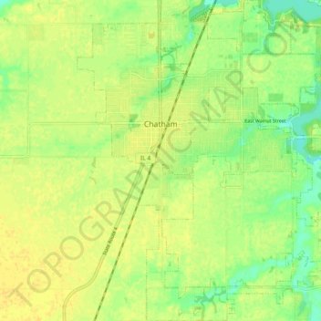
Name: Chatham topographic map, elevation, terrain.

Location: Chatham, Sangamon County, Illinois, 62629, United States (39.63277 -89.72837 39.70332 -89.65138)

Average elevation: 600 ft

Minimum elevation: 554 ft

Maximum elevation: 623 ft

Sangamon County trails, hiking, mountain biking, running and outdoor activities

Other topographic maps

Click on a map to view its topography, its elevation and its terrain.

Farmingdale

United States > Illinois > Sangamon County

Average elevation: 591 ft

Bates

United States > Illinois > Sangamon County

Average elevation: 636 ft

Gear up for your next adventure:

🏕️Tent Footprint - Protect your tent base from wear
🧯Emergency Survival Kit - All‑in‑one survival essentials for the backcountry
📚Navigation Handbooks - Master the art of reading topographic maps and using a compass
🔦Compact Flashlight - Reliable flashlight for emergencies
📡Handheld GPS Device - Reliable handheld GPS for outdoor navigation

As an Amazon Associate, this site earns from qualifying purchases at no extra cost to you.