Geolocate

Crathie topographic map

Click on the map to display elevation.

About this map

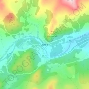
Name: Crathie topographic map, elevation, terrain.

Location: Crathie, Aberdeenshire, Scotland, AB35 5UL, United Kingdom (57.01950 -3.23496 57.05950 -3.19496)

Average elevation: 1,178 ft

Minimum elevation: 837 ft

Maximum elevation: 1,929 ft

Other topographic maps

Click on a map to view its topography, its elevation and its terrain.

Forgue

United Kingdom > Scotland > Aberdeenshire

Average elevation: 371 ft

Gear up for your next adventure:

🥘Titanium Cookware - Durable, featherlight pots and pans for backpacking
📶Satellite Messenger - Communication device off‑grid
🛡️Insect Repellent - Protection against bugs during outdoor activities
📖Nature Tracking Books - Learn to track wildlife and terrain
🏔️Mountain Trail Maps - High‑detail maps for popular peaks

As an Amazon Associate, this site earns from qualifying purchases at no extra cost to you.