Geolocate

Aboite topographic map

Click on the map to display elevation.

About this map

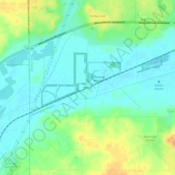
Name: Aboite topographic map, elevation, terrain.

Location: Aboite, Allen County, Indiana, 46783, United States (40.98088 -85.33803 41.02088 -85.29803)

Average elevation: 784 ft

Minimum elevation: 741 ft

Maximum elevation: 869 ft

Allen County trails, hiking, mountain biking, running and outdoor activities

Other topographic maps

Click on a map to view its topography, its elevation and its terrain.

Leo-Cedarville

United States > Indiana > Allen County

Average elevation: 804 ft

Monroeville

United States > Indiana > Allen County

Average elevation: 794 ft

Woodburn

United States > Indiana > Allen County

Average elevation: 748 ft

New Haven

United States > Indiana > Allen County

Average elevation: 778 ft

Gear up for your next adventure:

📷Action Cameras - Rugged cameras to document your journeys across rugged terrain
🥘Titanium Cookware - Durable, featherlight pots and pans for backpacking
🗃️Trail First Aid Kit - Essential kit for outdoor injuries and emergencies
🔋Solar Power Banks - Keep your GPS and phone charged in remote wilderness areas
📡GPS Antenna Upgrade - Enhance GPS reception in remote terrain

As an Amazon Associate, this site earns from qualifying purchases at no extra cost to you.