
Make a donation
Gear up for your next adventure:
As an Amazon Associate, this site earns from qualifying purchases at no extra cost to you.
Tannenboden topographic map
Click on the map to display elevation.
Make a donation
Gear up for your next adventure:
As an Amazon Associate, this site earns from qualifying purchases at no extra cost to you.
About this map
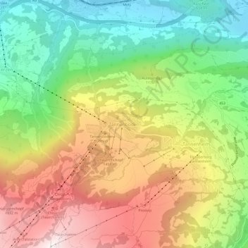
Name: Tannenboden topographic map, elevation, terrain.
Average elevation: 3,615 ft
Minimum elevation: 1,385 ft
Maximum elevation: 6,342 ft
Make a donation
Gear up for your next adventure:
As an Amazon Associate, this site earns from qualifying purchases at no extra cost to you.
Other topographic maps
Click on a map to view its topography, its elevation and its terrain.
Sargans
Suisse > Saint-Gall > Wahlkreis Sarganserland
La cité historique est située à l'intersection des axes ferroviaires et autoroutiers nord-sud (Saint-Gall-Coire) et ouest-est (Zurich-Coire), au pied du Gonzen qui culmine à 1 380 mètres d’altitude.
Average elevation: 2,320 ft
Make a donation
Gear up for your next adventure:
As an Amazon Associate, this site earns from qualifying purchases at no extra cost to you.