
Thank you for supporting this site ❤️
Make a donation
Make a donation
Gear up for your next adventure:
As an Amazon Associate, this site earns from qualifying purchases at no extra cost to you.
Fenerköy topographic map
Click on the map to display elevation.
Thank you for supporting this site ❤️
Make a donation
Make a donation
Gear up for your next adventure:
As an Amazon Associate, this site earns from qualifying purchases at no extra cost to you.
About this map
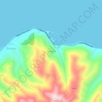
Name: Fenerköy topographic map, elevation, terrain.
Location: Fenerköy, Çarşıbaşı, Trabzon, Black Sea Region, Turkey (41.07778 39.40763 41.11778 39.44763)
Average elevation: 515 ft
Minimum elevation: 0 ft
Maximum elevation: 1,814 ft
Thank you for supporting this site ❤️
Make a donation
Make a donation
Gear up for your next adventure:
As an Amazon Associate, this site earns from qualifying purchases at no extra cost to you.