
Totana topographic map
Interactive map
Click on the map to display elevation.
About this map
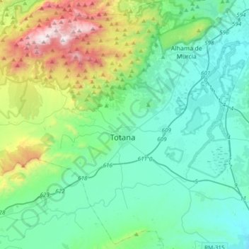
Name: Totana topographic map, elevation, terrain.
Location: Totana, Bajo Guadalentín, Murcia, 30850, Spanje (37.66749 -1.67139 37.89645 -1.36933)
Average elevation: 1,388 ft
Minimum elevation: 361 ft
Maximum elevation: 5,164 ft
Other topographic maps
Click on a map to view its topography, its elevation and its terrain.
Mazarrón
Spanje > Murcia > Bajo Guadalentín
Mazarrón, Bajo Guadalentín, Murcia, Spanje
Average elevation: 492 ft
El Saladillo
Spanje > Murcia > Bajo Guadalentín > Mazarrón
El Saladillo, Mazarrón, Bajo Guadalentín, Murcia, 30875, Spanje
Average elevation: 554 ft