
Mazarrón topographic map
Interactive map
Click on the map to display elevation.
About this map
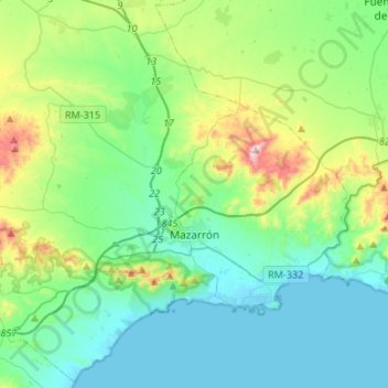
Name: Mazarrón topographic map, elevation, terrain.
Location: Mazarrón, Bajo Guadalentín, Murcia, Spanje (37.51728 -1.47576 37.72402 -1.20824)
Average elevation: 492 ft
Minimum elevation: -3 ft
Maximum elevation: 2,241 ft
Other topographic maps
Click on a map to view its topography, its elevation and its terrain.
Totana
Spanje > Murcia > Bajo Guadalentín
Totana, Bajo Guadalentín, Murcia, 30850, Spanje
Average elevation: 1,388 ft
El Saladillo
Spanje > Murcia > Bajo Guadalentín > Mazarrón
El Saladillo, Mazarrón, Bajo Guadalentín, Murcia, 30875, Spanje
Average elevation: 554 ft