
Thank you for supporting this site ❤️
Make a donation
Make a donation
Gear up for your next adventure:
As an Amazon Associate, this site earns from qualifying purchases at no extra cost to you.
Torrelles topographic map
Click on the map to display elevation.
Thank you for supporting this site ❤️
Make a donation
Make a donation
Gear up for your next adventure:
As an Amazon Associate, this site earns from qualifying purchases at no extra cost to you.
About this map
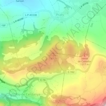
Name: Torrelles topographic map, elevation, terrain.
Location: Torrelles, Prats i Sansor, Cerdaña, Lérida, Cataluña, España (42.35564 1.83478 42.35574 1.83488)
Average elevation: 3,930 ft
Minimum elevation: 3,478 ft
Maximum elevation: 4,580 ft
Thank you for supporting this site ❤️
Make a donation
Make a donation
Gear up for your next adventure:
As an Amazon Associate, this site earns from qualifying purchases at no extra cost to you.