
Make a donation
Gear up for your next adventure:
As an Amazon Associate, this site earns from qualifying purchases at no extra cost to you.
Flotsenberg topographic map
Click on the map to display elevation.
Make a donation
Gear up for your next adventure:
As an Amazon Associate, this site earns from qualifying purchases at no extra cost to you.
About this map
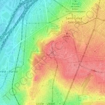
Name: Flotsenberg topographic map, elevation, terrain.
Location: Flotsenberg, Forest, Bruxelles-Capitale, 1190, Belgique (50.81660 4.33672 50.81670 4.33682)
Average elevation: 213 ft
Minimum elevation: 59 ft
Maximum elevation: 354 ft
Make a donation
Gear up for your next adventure:
As an Amazon Associate, this site earns from qualifying purchases at no extra cost to you.
Other topographic maps
Click on a map to view its topography, its elevation and its terrain.
Parc Duden
Belgique > Bruxelles-Capitale > Forest
Le parc Duden (en néerlandais : Dudenpark) est un parc bruxellois d’environ 24 hectares, situé dans la commune de Forest, sur le flanc droit de la vallée de la Senne au sud du parc de Forest. Son relief est varié, son point le plus élevé est à 90 m d'altitude et son point le plus bas à 55 m. On peut…
Average elevation: 184 ft
Make a donation
Gear up for your next adventure:
As an Amazon Associate, this site earns from qualifying purchases at no extra cost to you.