
Make a donation
Gear up for your next adventure:
As an Amazon Associate, this site earns from qualifying purchases at no extra cost to you.
La Estacada topographic map
Click on the map to display elevation.
Make a donation
Gear up for your next adventure:
As an Amazon Associate, this site earns from qualifying purchases at no extra cost to you.
About this map
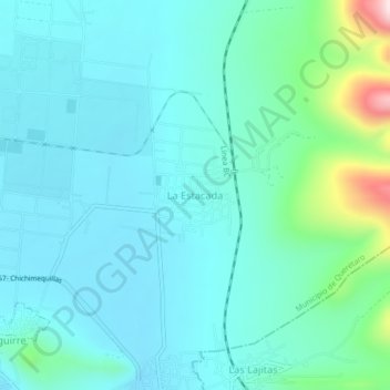
Name: La Estacada topographic map, elevation, terrain.
Average elevation: 6,844 ft
Minimum elevation: 6,614 ft
Maximum elevation: 7,989 ft
Make a donation
Gear up for your next adventure:
As an Amazon Associate, this site earns from qualifying purchases at no extra cost to you.
Other topographic maps
Click on a map to view its topography, its elevation and its terrain.
Querétaro
Mexico > Querétaro > Municipio de Querétaro
The municipality has rolling hills, mountain ranges and flatlands. Most of the rolling hills cross the territory from south to north, paralleling the Querétaro-San Luis Potosí highway. Most plains are located in the north, and are of sedimentary soil with some protrusions of volcanic rock. Altitude varies…
Average elevation: 6,302 ft
Querétaro
Mexico > Querétaro > Municipio de Querétaro
The municipality has rolling hills, mountain ranges and flatlands. Most of the rolling hills cross the territory from south to north, paralleling the Querétaro-San Luis Potosí highway. Most plains are located in the north, and are of sedimentary soil with some protrusions of volcanic rock. Altitude varies…
Average elevation: 6,319 ft
Make a donation
Gear up for your next adventure:
As an Amazon Associate, this site earns from qualifying purchases at no extra cost to you.
Delegación Josefa Vergara y Hernández
Mexico > Querétaro > Municipio de Querétaro
Average elevation: 6,424 ft
Parque Queretaro 2000
Mexico > Querétaro > Municipio de Querétaro > Querétaro
Average elevation: 6,079 ft
Make a donation
Gear up for your next adventure:
As an Amazon Associate, this site earns from qualifying purchases at no extra cost to you.
Delegación Josefa Vergara y Hernández
Mexico > Querétaro > Municipio de Querétaro
Average elevation: 6,424 ft