Geolocate

Sampaga topographic map

Click on the map to display elevation.

About this map

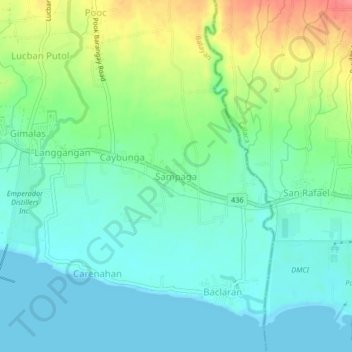
Name: Sampaga topographic map, elevation, terrain.

Location: Sampaga, Balayan, Batangas, Calabarzon, 4213, Philippines (13.92274 120.74700 13.96274 120.78700)

Average elevation: 72 ft

Minimum elevation: 0 ft

Maximum elevation: 236 ft

Gear up for your next adventure:

🧭Orienteering Set - Complete compass and map reading kit
🔊Portable Camp Speaker - Music and alerts at camp
🪶Multi‑Purpose Knife - Useful blade for camp and trail
🧭Map Reading Tools - Tools and kits for map navigation
🪓Survival Multi‑Tool - Versatile tool for camp and trail tasks

As an Amazon Associate, this site earns from qualifying purchases at no extra cost to you.