Geolocate

Closs topographic map

Click on the map to display elevation.

About this map

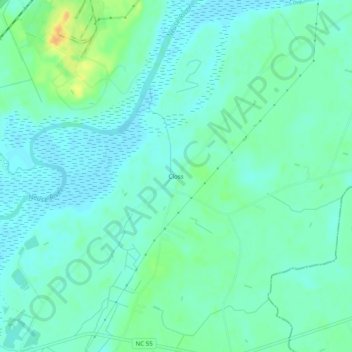
Name: Closs topographic map, elevation, terrain.

Location: Closs, Lenoir County, North Carolina, United States (35.29322 -77.48246 35.33322 -77.44246)

Average elevation: 33 ft

Minimum elevation: 3 ft

Maximum elevation: 112 ft

Lenoir County trails, hiking, mountain biking, running and outdoor activities

Other topographic maps

Click on a map to view its topography, its elevation and its terrain.

Pink Hill

United States > North Carolina > Lenoir County

Average elevation: 141 ft

Gear up for your next adventure:

🪑Ultralight Camp Chairs - Portable seating for resting after a long day of mapping
📡Handheld GPS Device - Reliable handheld GPS for outdoor navigation
Backpacking Tents - Weight-optimized shelters for multi-day topographic surveys
🧺Microfiber Travel Towels - Compact and fast-drying towels for trail use
🧭Hiking Compass - Precision compass for reliable navigation in the wilderness

As an Amazon Associate, this site earns from qualifying purchases at no extra cost to you.