
Make a donation
Gear up for your next adventure:
As an Amazon Associate, this site earns from qualifying purchases at no extra cost to you.
Matosinhos topographic map
Click on the map to display elevation.
Make a donation
Gear up for your next adventure:
As an Amazon Associate, this site earns from qualifying purchases at no extra cost to you.
About this map
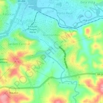
Name: Matosinhos topographic map, elevation, terrain.
Average elevation: 3,035 ft
Minimum elevation: 2,900 ft
Maximum elevation: 3,294 ft
Make a donation
Gear up for your next adventure:
As an Amazon Associate, this site earns from qualifying purchases at no extra cost to you.
Other topographic maps
Click on a map to view its topography, its elevation and its terrain.
Serra do Lenheiro
Brasil > Minas Gerais > São João del-Rei > São Gonçalo do Amarante
Average elevation: 3,455 ft
Santo Antônio do Rio das Mortes Pequeno
Brasil > Minas Gerais > São João del-Rei > Santo Antônio do Rio das Mortes Pequeno
Average elevation: 3,107 ft
Make a donation
Gear up for your next adventure:
As an Amazon Associate, this site earns from qualifying purchases at no extra cost to you.
Brumado de Baixo
Brasil > Minas Gerais > São João del-Rei > São Gonçalo do Amarante
Average elevation: 3,238 ft