Geolocate

Kinston topographic map

Click on the map to display elevation.

About this map

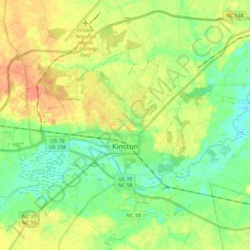
Name: Kinston topographic map, elevation, terrain.

Location: Kinston, Lenoir County, North Carolina, United States (35.22583 -77.66264 35.32253 -77.49801)

Average elevation: 62 ft

Minimum elevation: 7 ft

Maximum elevation: 131 ft

Lenoir County trails, hiking, mountain biking, running and outdoor activities

Other topographic maps

Click on a map to view its topography, its elevation and its terrain.

Savannah

United States > North Carolina > Lenoir County

Average elevation: 69 ft

Gear up for your next adventure:

🔪Outdoor Multitools - Essential survival tools for gear repair and field use
⛑️Personal Locator Beacon - Safety beacon for emergencies
🚪Portable Camp Chair - Foldable chair for comfort at camp
🎁Geography Themed Gifts - Unique gift ideas for map lovers and geography enthusiasts
🪶Paracord Bracelet - Survival bracelet with built‑in tools

As an Amazon Associate, this site earns from qualifying purchases at no extra cost to you.