Geolocate

Borgetto topographic map

Click on the map to display elevation.

About this map

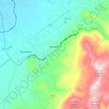
Name: Borgetto topographic map, elevation, terrain.

Location: Borgetto, Palermo, Sicily, 90042, Italy (38.00821 13.12065 38.07603 13.19983)

Average elevation: 1,407 ft

Minimum elevation: 367 ft

Maximum elevation: 3,894 ft

Other topographic maps

Click on a map to view its topography, its elevation and its terrain.

Sorgente di Montescuro

Italy > Sicily > Palermo > Prizzi

Average elevation: 2,726 ft

Bellacera

Italy > Sicily > Palermo > Santa Flavia

Average elevation: 531 ft

Finale

Italy > Sicily > Palermo

Average elevation: 276 ft

Santa Lucia

Italy > Sicily > Palermo > Cefalù

Average elevation: 167 ft

San Carlo

Italy > Sicily > Palermo > Chiusa Sclafani

Average elevation: 955 ft

Gear up for your next adventure:

🧺Microfiber Travel Towels - Compact and fast-drying towels for trail use
🌧️Backpack Rain Cover - Keep gear dry in wet weather
🖼️Topo Map Wall Art - Decorative topographic prints of famous peaks and regions
🏥Hiking First Aid Kits - Comprehensive medical kits for remote trail injuries
📻Weather Alert Radios - Stay informed of storm risks while off-the-grid

As an Amazon Associate, this site earns from qualifying purchases at no extra cost to you.