Geolocate

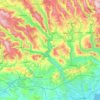
Rhydyfelin topographic map

Click on the map to display elevation.

About this map

Name: Rhydyfelin topographic map, elevation, terrain.

Location: Rhydyfelin, Pontypridd, Rhondda Cynon Taf, Wales, CF37 5LY, United Kingdom (51.56496 -3.32646 51.60496 -3.28646)

Average elevation: 482 ft

Minimum elevation: 121 ft

Maximum elevation: 1,201 ft

Other topographic maps

Click on a map to view its topography, its elevation and its terrain.
River Taff

United Kingdom > Wales > Rhondda Cynon Taf > Pontypridd

Average elevation: 643 ft

Gear up for your next adventure:

🧤Hiking Gloves - Protective gloves for rugged trails
🧢Outdoor Hiking Hat - Sun protection hat for outdoor explorers
📚Navigation Handbooks - Master the art of reading topographic maps and using a compass
☕Camping Coffee Makers - Enjoy premium coffee at the summit or campsite
🧭Compass with Lanyard - Easy‑carry compass for navigation

As an Amazon Associate, this site earns from qualifying purchases at no extra cost to you.