
Thank you for supporting this site ❤️
Make a donation
Make a donation
Gear up for your next adventure:
As an Amazon Associate, this site earns from qualifying purchases at no extra cost to you.
Catanzaro topographic map
Click on the map to display elevation.
Thank you for supporting this site ❤️
Make a donation
Make a donation
Gear up for your next adventure:
As an Amazon Associate, this site earns from qualifying purchases at no extra cost to you.
About this map
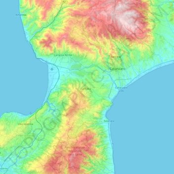
Name: Catanzaro topographic map, elevation, terrain.
Location: Catanzaro, Calabria, Italy (38.46334 16.09549 39.19424 16.92060)
Average elevation: 1,158 ft
Minimum elevation: -3 ft
Maximum elevation: 5,761 ft
Thank you for supporting this site ❤️
Make a donation
Make a donation
Gear up for your next adventure:
As an Amazon Associate, this site earns from qualifying purchases at no extra cost to you.
Other topographic maps
Click on a map to view its topography, its elevation and its terrain.
Sant'Antonio
Italy > Calabria > Crotone > Isola di Capo Rizzuto > Sant'Antonio
Average elevation: 72 ft