
Sanare topographic map
Click on the map to display elevation.
About this map
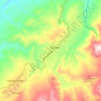
Name: Sanare topographic map, elevation, terrain.
Average elevation: 3,773 ft
Minimum elevation: 1,808 ft
Maximum elevation: 7,329 ft
Other topographic maps
Click on a map to view its topography, its elevation and its terrain.
Parque Nacional El Guache
Venezuela > Estado Lara > Municipio Andrés Eloy Blanco
Average elevation: 3,750 ft
Parque Nacional El Guache
Venezuela > Estado Lara > Municipio Andrés Eloy Blanco
Average elevation: 3,750 ft