Geolocate

Brawley topographic map

Click on the map to display elevation.

About this map

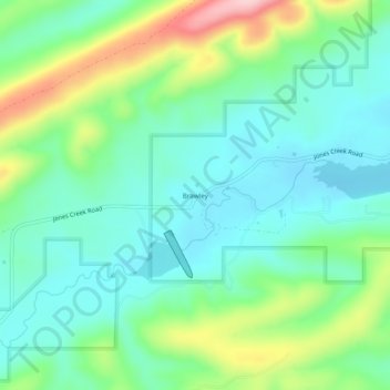
Name: Brawley topographic map, elevation, terrain.

Location: Brawley, Scott County, Arkansas, United States (34.83455 -94.33272 34.87455 -94.29272)

Average elevation: 981 ft

Minimum elevation: 781 ft

Maximum elevation: 1,483 ft

Scott County trails, hiking, mountain biking, running and outdoor activities

Other topographic maps

Click on a map to view its topography, its elevation and its terrain.

Mansfield

United States > Arkansas > Scott County

Average elevation: 650 ft

Waldron

United States > Arkansas > Scott County

Average elevation: 699 ft

Waldron

United States > Arkansas > Scott County

Average elevation: 699 ft

Gear up for your next adventure:

🛠️Outdoor Gear Repair Kit - Essential tools to fix gear on the trail
🧭Hiking Compass - Precision compass for reliable navigation in the wilderness
🪶Wildlife Field Guides - Learn animal tracking and species ID
👟Men's Trail Runners - Lightweight footwear for fast-paced exploration and light hiking
🦟Ultrasonic Repellers - Create a bug-free zone at your camp or rest stop

As an Amazon Associate, this site earns from qualifying purchases at no extra cost to you.