
Make a donation
Gear up for your next adventure:
As an Amazon Associate, this site earns from qualifying purchases at no extra cost to you.
Clarksville topographic map
Click on the map to display elevation.
Make a donation
Gear up for your next adventure:
As an Amazon Associate, this site earns from qualifying purchases at no extra cost to you.
About this map
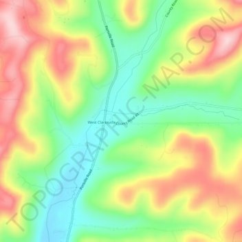
Name: Clarksville topographic map, elevation, terrain.
Average elevation: 1,883 ft
Minimum elevation: 1,529 ft
Maximum elevation: 2,316 ft
Allegany County trails, hiking, mountain biking, running and outdoor activities
Make a donation
Gear up for your next adventure:
As an Amazon Associate, this site earns from qualifying purchases at no extra cost to you.
Other topographic maps
Click on a map to view its topography, its elevation and its terrain.
Village of Almond
United States > New York > Allegany County > Town of Almond
Average elevation: 1,539 ft
Make a donation
Gear up for your next adventure:
As an Amazon Associate, this site earns from qualifying purchases at no extra cost to you.
Make a donation
Gear up for your next adventure:
As an Amazon Associate, this site earns from qualifying purchases at no extra cost to you.
Make a donation
Gear up for your next adventure:
As an Amazon Associate, this site earns from qualifying purchases at no extra cost to you.
Make a donation
Gear up for your next adventure:
As an Amazon Associate, this site earns from qualifying purchases at no extra cost to you.
Friendship
United States > New York > Allegany County > Town of Friendship
Average elevation: 1,752 ft
Town of Alfred
United States > New York > Allegany County
There is a small stream known as Canacadea Creek, that flows throughout the year from south to north. This stream flows to the Canisteo River, which is a tributary to the Susquehanna River watershed. The topography is steep hill country as it is part of the Allegheny Plateau, being the northern part of the…
Average elevation: 2,067 ft
Make a donation
Gear up for your next adventure:
As an Amazon Associate, this site earns from qualifying purchases at no extra cost to you.
Make a donation
Gear up for your next adventure:
As an Amazon Associate, this site earns from qualifying purchases at no extra cost to you.
Village of Andover
United States > New York > Allegany County > Town of Andover
Average elevation: 1,841 ft