Geolocate

Abbotskerswell topographic map

Click on the map to display elevation.

About this map

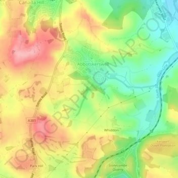
Name: Abbotskerswell topographic map, elevation, terrain.

Location: Abbotskerswell, Teignbridge, Devon, Devon and Torbay, England, United Kingdom (50.49309 -3.63335 50.51592 -3.58863)

Average elevation: 217 ft

Minimum elevation: 10 ft

Maximum elevation: 413 ft

Other topographic maps

Click on a map to view its topography, its elevation and its terrain.

Gear up for your next adventure:

🖼️Topo Map Wall Art - Decorative topographic prints of famous peaks and regions
❄️Traction Cleats - Prevent slips on icy trails during winter hikes
🌲Outdoor Survival Books - Best books on survival skills
🔪Outdoor Multitools - Essential survival tools for gear repair and field use
🪶Compact Camp Shovel - Folding shovel for campsite tasks

As an Amazon Associate, this site earns from qualifying purchases at no extra cost to you.