
Make a donation
Gear up for your next adventure:
As an Amazon Associate, this site earns from qualifying purchases at no extra cost to you.
Somersworth topographic map
Click on the map to display elevation.
Make a donation
Gear up for your next adventure:
As an Amazon Associate, this site earns from qualifying purchases at no extra cost to you.
Somersworth
According to the United States Census Bureau, the city has a total area of 10.0 square miles (25.9 km2), of which 9.8 square miles (25.4 km2) are land and 0.2 square miles (0.5 km2) are water, comprising 1.96% of the city. Somersworth is bordered to the northeast by the Salmon Falls River, which is also the state boundary with Maine. The highest point in Somersworth is Prospect Hill rising just west of the city center, on which the city reservoir is built. The hill's elevation is approximately 310 feet (94 m) above sea level.
Make a donation
Gear up for your next adventure:
As an Amazon Associate, this site earns from qualifying purchases at no extra cost to you.
About this map
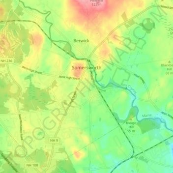
Name: Somersworth topographic map, elevation, terrain.
Average elevation: 184 ft
Minimum elevation: 26 ft
Maximum elevation: 394 ft
Strafford County trails, hiking, mountain biking, running and outdoor activities
Make a donation
Gear up for your next adventure:
As an Amazon Associate, this site earns from qualifying purchases at no extra cost to you.
Other topographic maps
Click on a map to view its topography, its elevation and its terrain.
Milton Three Ponds Dam
United States > New Hampshire > Strafford County > Milton
Average elevation: 525 ft
Make a donation
Gear up for your next adventure:
As an Amazon Associate, this site earns from qualifying purchases at no extra cost to you.