
Thank you for supporting this site ❤️
Make a donation
Make a donation
Gear up for your next adventure:
As an Amazon Associate, this site earns from qualifying purchases at no extra cost to you.
Bedfordshire topographic map
Click on the map to display elevation.
Thank you for supporting this site ❤️
Make a donation
Make a donation
Gear up for your next adventure:
As an Amazon Associate, this site earns from qualifying purchases at no extra cost to you.
About this map
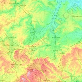
Name: Bedfordshire topographic map, elevation, terrain.
Location: Bedfordshire, Central Bedfordshire, England, United Kingdom (51.80509 -0.70218 52.32296 -0.14396)
Average elevation: 266 ft
Minimum elevation: 7 ft
Maximum elevation: 820 ft
Thank you for supporting this site ❤️
Make a donation
Make a donation
Gear up for your next adventure:
As an Amazon Associate, this site earns from qualifying purchases at no extra cost to you.