
Make a donation
Gear up for your next adventure:
As an Amazon Associate, this site earns from qualifying purchases at no extra cost to you.
Lake Rukwa topographic map
Click on the map to display elevation.
Make a donation
Gear up for your next adventure:
As an Amazon Associate, this site earns from qualifying purchases at no extra cost to you.
Lake Rukwa
The alkaline Lake Rukwa lies midway between Lake Tanganyika and Lake Malawi at an elevation of about 800 metres (2,600 ft), in a parallel branch of the rift system. Almost half of the lake lies in Uwanda Game Reserve.
Make a donation
Gear up for your next adventure:
As an Amazon Associate, this site earns from qualifying purchases at no extra cost to you.
About this map
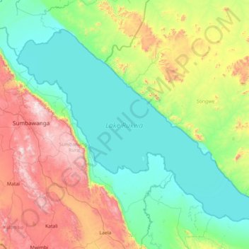
Name: Lake Rukwa topographic map, elevation, terrain.
Location: Lake Rukwa, Songwe Region, Southern Highlands Zone, Tanzania (-8.50863 31.53946 -7.42159 32.93349)
Average elevation: 3,901 ft
Minimum elevation: 2,592 ft
Maximum elevation: 7,956 ft
Make a donation
Gear up for your next adventure:
As an Amazon Associate, this site earns from qualifying purchases at no extra cost to you.
Other topographic maps
Click on a map to view its topography, its elevation and its terrain.
Make a donation
Gear up for your next adventure:
As an Amazon Associate, this site earns from qualifying purchases at no extra cost to you.