Geolocate

Nalgonda topographic map

Click on the map to display elevation.

Nalgonda

Nalgonda is located at 17°03′00″N 79°16′00″E / 17.050°N 79.2667°E / 17.050; 79.2667. It has an average elevation of 420 metres (1,380 ft).

Wikipedia (CC-BY-SA 3.0)

About this map

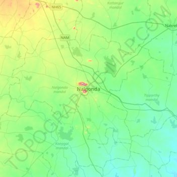
Name: Nalgonda topographic map, elevation, terrain.

Location: Nalgonda, Nalgonda mandal, Nalgonda District, Telangana, 508001, India (16.89044 79.10692 17.21044 79.42692)

Average elevation: 719 ft

Minimum elevation: 495 ft

Maximum elevation: 1,460 ft

Gear up for your next adventure:

🥘Titanium Cookware - Durable, featherlight pots and pans for backpacking
🥤Water Filter Bottle - All‑in‑one filter bottle for safe hydration
🧦Hiking Socks - Comfortable socks to prevent blisters on long hikes
🧣Merino Neck Gaiters - Multi-functional headwear for wind and sun protection
🩳Quick‑Dry Hiking Shorts - Comfortable and quick‑dry shorts for summer hiking

As an Amazon Associate, this site earns from qualifying purchases at no extra cost to you.