
Make a donation
Gear up for your next adventure:
As an Amazon Associate, this site earns from qualifying purchases at no extra cost to you.
Colstrip topographic map
Click on the map to display elevation.
Make a donation
Gear up for your next adventure:
As an Amazon Associate, this site earns from qualifying purchases at no extra cost to you.
Colstrip
South of town 23 miles (37 km), is Deer Medicine Rocks, a National Historic Landmark. These sandstone cliffs are covered with petroglyphs and pictographs. Hills covered in sandstone formations are typical of this area. The topography in the county is mostly rolling with small hills. Deer and pronghorn are plentiful.
Make a donation
Gear up for your next adventure:
As an Amazon Associate, this site earns from qualifying purchases at no extra cost to you.
About this map
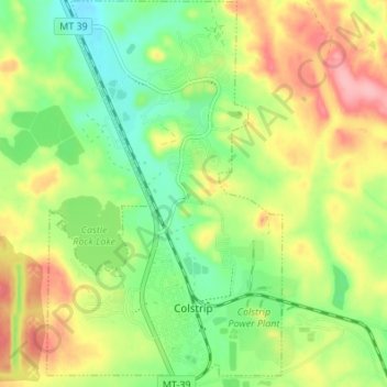
Name: Colstrip topographic map, elevation, terrain.
Location: Colstrip, Rosebud County, Montana, 59323, United States (45.87448 -106.64953 45.92179 -106.60790)
Average elevation: 3,304 ft
Minimum elevation: 3,136 ft
Maximum elevation: 3,524 ft
Rosebud County trails, hiking, mountain biking, running and outdoor activities
Make a donation
Gear up for your next adventure:
As an Amazon Associate, this site earns from qualifying purchases at no extra cost to you.