Geolocate

Sixth topographic map

Click on the map to display elevation.

About this map

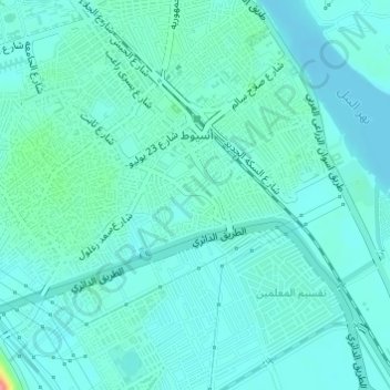
Name: Sixth topographic map, elevation, terrain.

Location: Sixth, Asyut, 71511, Egypt (27.16361 31.17453 27.18652 31.20199)

Average elevation: 187 ft

Minimum elevation: 144 ft

Maximum elevation: 427 ft

Other topographic maps

Click on a map to view its topography, its elevation and its terrain.

Al Qusiya

Egypt > Asyut

Average elevation: 157 ft

Al Badari

Egypt > Asyut

Average elevation: 230 ft

Gear up for your next adventure:

🥘Titanium Cookware - Durable, featherlight pots and pans for backpacking
🧢Outdoor Hiking Hat - Sun protection hat for outdoor explorers
Backpacking Tents - Weight-optimized shelters for multi-day topographic surveys
🔦Compact Flashlight - Reliable flashlight for emergencies
🔭Telescopic Hiking Pole - Adjustable pole for hiking stability

As an Amazon Associate, this site earns from qualifying purchases at no extra cost to you.