
Garson topographic map
Click on the map to display elevation.
About this map
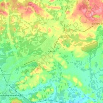
Name: Garson topographic map, elevation, terrain.
Average elevation: 958 ft
Minimum elevation: 823 ft
Maximum elevation: 1,155 ft
Other topographic maps
Click on a map to view its topography, its elevation and its terrain.
Lake Laurentian Conservation Area
Canada > Ontario > Sudbury District > Greater Sudbury > McFarlane Lake
Average elevation: 866 ft
Windy Lake
Canada > Ontario > Sudbury District > Greater Sudbury > Onaping
Average elevation: 1,191 ft
Lake Laurentian
Canada > Ontario > Sudbury District > Greater Sudbury > McFarlane Lake
Average elevation: 886 ft