Geolocate

Shoeburyness topographic map

Click on the map to display elevation.

About this map

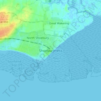
Name: Shoeburyness topographic map, elevation, terrain.

Location: Shoeburyness, Southend-on-Sea, Essex, England, SS3 9AB, United Kingdom (51.48974 0.75620 51.56974 0.83620)

Average elevation: 10 ft

Minimum elevation: -7 ft

Maximum elevation: 98 ft

Other topographic maps

Click on a map to view its topography, its elevation and its terrain.

Gear up for your next adventure:

🧭Hiking Compass - Precision compass for reliable navigation in the wilderness
🚑Emergency Bivvies - Heat-reflective sleeping bags for survival situations
💧Water Filtration Bottles - Safely drink from streams and lakes while exploring
🏕️Tent Footprint - Protect your tent base from wear
🪶Camping Sleeping Pad - Comfortable sleeping pad for backpacking

As an Amazon Associate, this site earns from qualifying purchases at no extra cost to you.