Geolocate

Navarre topographic map

Click on the map to display elevation.

👉 Easily get elevation data in JSON, GeoTIFF and KML formats using Elevation API
Thank you for supporting this site ❤️
Make a donation

About this map

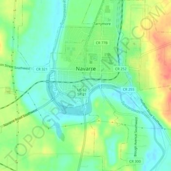
Name: Navarre topographic map, elevation, terrain.

Location: Navarre, Stark County, Ohio, United States (40.70611 -81.53096 40.73743 -81.48974)

Average elevation: 971 ft

Minimum elevation: 906 ft

Maximum elevation: 1,079 ft

Stark County trails, hiking, mountain biking, running and outdoor activities

Gear up for your next adventure:

🎒Hydration Pack - Hands‑free water reservoir for long hikes
👟Men's Trail Runners - Lightweight footwear for fast-paced exploration and light hiking
❄️Traction Cleats - Prevent slips on icy trails during winter hikes
🧯Portable Fire Pit - Compact fire pit for camping spots
🌐World Map Poster - Decorative world maps with topographic info

As an Amazon Associate, this site earns from qualifying purchases at no extra cost to you.