
Thank you for supporting this site ❤️
Make a donation
Make a donation
Gear up for your next adventure:
As an Amazon Associate, this site earns from qualifying purchases at no extra cost to you.
Palmira topographic map
Click on the map to display elevation.
Thank you for supporting this site ❤️
Make a donation
Make a donation
Gear up for your next adventure:
As an Amazon Associate, this site earns from qualifying purchases at no extra cost to you.
About this map
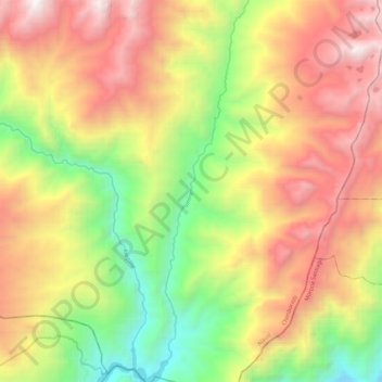
Name: Palmira topographic map, elevation, terrain.
Location: Palmira, Achupallas, Alausí, Chimborazo, Ecuador (-2.55955 -78.55645 -2.44259 -78.52486)
Average elevation: 9,820 ft
Minimum elevation: 6,247 ft
Maximum elevation: 13,435 ft
Thank you for supporting this site ❤️
Make a donation
Make a donation
Gear up for your next adventure:
As an Amazon Associate, this site earns from qualifying purchases at no extra cost to you.