Geolocate

Troy topographic map

Click on the map to display elevation.

About this map

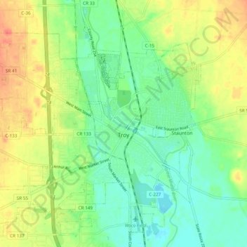
Name: Troy topographic map, elevation, terrain.

Location: Troy, Miami County, Ohio, 45373, United States (40.00959 -84.26842 40.07604 -84.17359)

Average elevation: 860 ft

Minimum elevation: 797 ft

Maximum elevation: 945 ft

Miami County trails, hiking, mountain biking, running and outdoor activities

Other topographic maps

Click on a map to view its topography, its elevation and its terrain.

Diltz Corners

United States > Ohio > Miami County > Troy

Average elevation: 922 ft

Gear up for your next adventure:

Solar GPS Watches - Advanced multisport watches with built-in topographic maps
🦶Carbon Trekking Poles - Reduce knee impact on steep descents with ultra-light poles
🧭GPS Watch Accessories - Bands and chargers for GPS watches
😴Insulated Sleeping Pads - Compact and warm pads for high-elevation camping
👟Men's Trail Runners - Lightweight footwear for fast-paced exploration and light hiking

As an Amazon Associate, this site earns from qualifying purchases at no extra cost to you.