Geolocate

Benoa topographic map

Click on the map to display elevation.

About this map

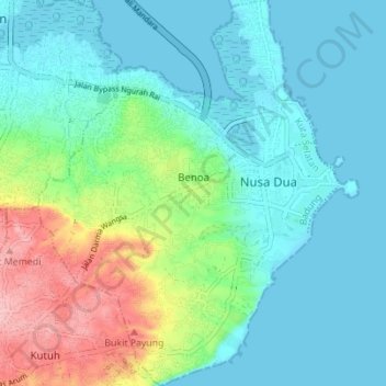
Name: Benoa topographic map, elevation, terrain.

Location: Benoa, Kuta Selatan, Bali, Indonesia (-8.83773 115.18275 -8.76946 115.24012)

Average elevation: 118 ft

Minimum elevation: -3 ft

Maximum elevation: 482 ft

Gear up for your next adventure:

🥤Water Filter Bottle - All‑in‑one filter bottle for safe hydration
🪶Thermal Camp Blanket - Extra warmth for cold nights
🧺Microfiber Travel Towels - Compact and fast-drying towels for trail use
🧭Orienteering Set - Complete compass and map reading kit
🪓Survival Multi‑Tool - Versatile tool for camp and trail tasks

As an Amazon Associate, this site earns from qualifying purchases at no extra cost to you.