Geolocate

Atlee topographic map

Click on the map to display elevation.

About this map

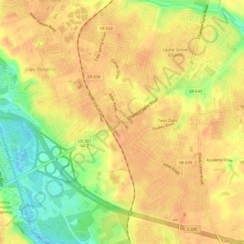
Name: Atlee topographic map, elevation, terrain.

Location: Atlee, Hanover County, Virginia, 23116, United States (37.63097 -77.41941 37.67097 -77.37941)

Average elevation: 171 ft

Minimum elevation: 79 ft

Maximum elevation: 217 ft

Hanover County trails, hiking, mountain biking, running and outdoor activities

Other topographic maps

Click on a map to view its topography, its elevation and its terrain.

Mechanicsville

United States > Virginia > Hanover County > Atlee

Average elevation: 161 ft

Ashland

United States > Virginia > Hanover County

Average elevation: 217 ft

Ashland

United States > Virginia > Hanover County

Average elevation: 217 ft

Gear up for your next adventure:

🛶Inflatable Kayak - Portable kayak for rivers, lakes, and expeditions
🏥Hiking First Aid Kits - Comprehensive medical kits for remote trail injuries
🌧️Backpack Rain Cover - Keep gear dry in wet weather
🔪Outdoor Multitools - Essential survival tools for gear repair and field use
🖼️Topo Map Wall Art - Decorative topographic prints of famous peaks and regions

As an Amazon Associate, this site earns from qualifying purchases at no extra cost to you.