
Adeje topographic map
Click on the map to display elevation.
About this map
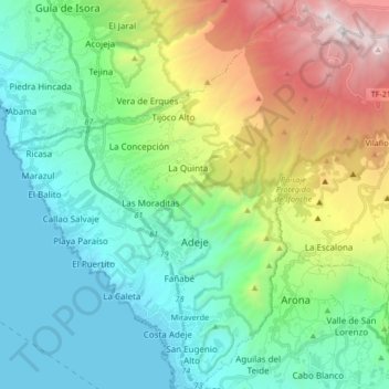
Name: Adeje topographic map, elevation, terrain.
Location: Adeje, Santa Cruz de Tenerife, Canary Islands, Spain (28.06591 -16.80217 28.21298 -16.66005)
Average elevation: 2,306 ft
Minimum elevation: 0 ft
Maximum elevation: 8,248 ft
Other topographic maps
Click on a map to view its topography, its elevation and its terrain.
Masca
Spain > Canary Islands > Buenavista del Norte
Masca is a small mountain village on the island of Tenerife. It was originally a Guanche settlement before the Spanish conquest in 1496. The village is now home to around 90 inhabitants. The village lies at an altitude of 650 m in the Macizo de Teno mountains, which extend up to the northwesternmost point of…
Average elevation: 2,523 ft
La Cruz Chica
Spain > Canary Islands > San Cristóbal de La Laguna > El Ortigal
Average elevation: 1,988 ft
Parque de la Puerta de Tierra
Spain > Canary Islands > San Juan del Reparo (La Culata) > San Pedro de Daute
Average elevation: 597 ft