
Thank you for supporting this site ❤️
Make a donation
Make a donation
Gear up for your next adventure:
As an Amazon Associate, this site earns from qualifying purchases at no extra cost to you.
A Insua topographic map
Click on the map to display elevation.
Thank you for supporting this site ❤️
Make a donation
Make a donation
Gear up for your next adventure:
As an Amazon Associate, this site earns from qualifying purchases at no extra cost to you.
About this map
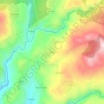
Name: A Insua topographic map, elevation, terrain.
Location: A Insua, Ponte Caldelas, Pontevedra, Galicia, 36826, España (42.34329 -8.54865 42.38329 -8.50865)
Average elevation: 787 ft
Minimum elevation: 46 ft
Maximum elevation: 1,696 ft
Thank you for supporting this site ❤️
Make a donation
Make a donation
Gear up for your next adventure:
As an Amazon Associate, this site earns from qualifying purchases at no extra cost to you.