Geolocate

Rossana topographic map

Click on the map to display elevation.

About this map

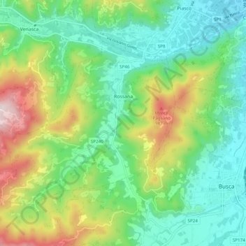
Name: Rossana topographic map, elevation, terrain.

Location: Rossana, Cuneo, Piedmont, Italy (44.51291 7.35766 44.55882 7.45422)

Average elevation: 2,172 ft

Minimum elevation: 1,470 ft

Maximum elevation: 3,714 ft

Gear up for your next adventure:

🧷Carabiner Set - Durable clips for gear attachment
📡GPS Antenna Upgrade - Enhance GPS reception in remote terrain
🔥Plasma Lighters - Windproof lighters that work in any weather condition
🧣Hiking Neck Gaiter - Multi‑use neck protection for outdoor weather
🛏️Cold Weather Sleeping Bag - Warm sleeping bag for cold conditions

As an Amazon Associate, this site earns from qualifying purchases at no extra cost to you.