
Thank you for supporting this site ❤️
Make a donation
Make a donation
Gear up for your next adventure:
As an Amazon Associate, this site earns from qualifying purchases at no extra cost to you.
Minfeng County topographic map
Click on the map to display elevation.
Thank you for supporting this site ❤️
Make a donation
Make a donation
Gear up for your next adventure:
As an Amazon Associate, this site earns from qualifying purchases at no extra cost to you.
About this map
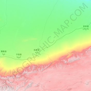
Name: Minfeng County topographic map, elevation, terrain.
Location: Minfeng County, Hotan Prefecture, Xinjiang, China (35.33689 82.39677 39.48444 84.98375)
Average elevation: 8,192 ft
Minimum elevation: 3,248 ft
Maximum elevation: 22,664 ft
Thank you for supporting this site ❤️
Make a donation
Make a donation
Gear up for your next adventure:
As an Amazon Associate, this site earns from qualifying purchases at no extra cost to you.