
Town of Dryden topographic map
Interactive map
Click on the map to display elevation.
About this map
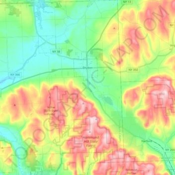
Name: Town of Dryden topographic map, elevation, terrain.
Location: Town of Dryden, Tompkins County, New York, United States (42.39623 -76.45407 42.55049 -76.25400)
Average elevation: 1,411 ft
Minimum elevation: 991 ft
Maximum elevation: 2,031 ft
Tompkins County trails, hiking, mountain biking, running and outdoor activities
Other topographic maps
Click on a map to view its topography, its elevation and its terrain.
Hartung-Boothroyd Observatory
United States > New York > Tompkins County > Town of Dryden > Varna
The primary 0.6m mirror was constructed from a Pyrex 1/8-scale test pouring as part of technology development for the Palomar Observatory 200-inch telescope. The mirror was polished and mounted in a lightweight tube in the late 1930s under Boothroyd's direction, but World War II deferred its planned use in a…
Average elevation: 1,565 ft