
Make a donation
Gear up for your next adventure:
As an Amazon Associate, this site earns from qualifying purchases at no extra cost to you.
Bel-Air topographic map
Click on the map to display elevation.
Make a donation
Gear up for your next adventure:
As an Amazon Associate, this site earns from qualifying purchases at no extra cost to you.
About this map
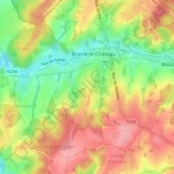
Name: Bel-Air topographic map, elevation, terrain.
Average elevation: 322 ft
Minimum elevation: 141 ft
Maximum elevation: 492 ft
Make a donation
Gear up for your next adventure:
As an Amazon Associate, this site earns from qualifying purchases at no extra cost to you.
Other topographic maps
Click on a map to view its topography, its elevation and its terrain.
Château des Comtes de Hornes
Belgique > Brabant wallon > Nivelles > Braine-le-Château
Average elevation: 282 ft
Square A. Godeau
Belgique > Brabant wallon > Nivelles > Braine-le-Château > Bel-Air
Average elevation: 289 ft
Make a donation
Gear up for your next adventure:
As an Amazon Associate, this site earns from qualifying purchases at no extra cost to you.