
Thank you for supporting this site ❤️
Make a donation
Make a donation
Gear up for your next adventure:
As an Amazon Associate, this site earns from qualifying purchases at no extra cost to you.
Gurpura topographic map
Click on the map to display elevation.
Thank you for supporting this site ❤️
Make a donation
Make a donation
Gear up for your next adventure:
As an Amazon Associate, this site earns from qualifying purchases at no extra cost to you.
About this map
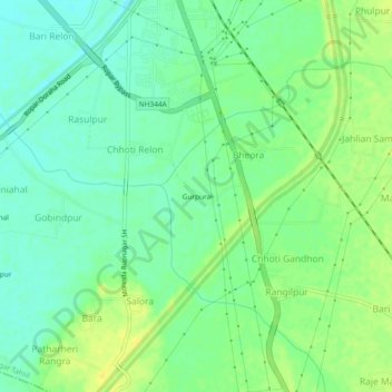
Name: Gurpura topographic map, elevation, terrain.
Location: Gurpura, Paprala, Rupnagar Tahsil, Rupnagar, Punjab, India (30.90995 76.51355 30.94995 76.55355)
Average elevation: 912 ft
Minimum elevation: 879 ft
Maximum elevation: 951 ft
Thank you for supporting this site ❤️
Make a donation
Make a donation
Gear up for your next adventure:
As an Amazon Associate, this site earns from qualifying purchases at no extra cost to you.