
Baharagora topographic map
Click on the map to display elevation.
About this map
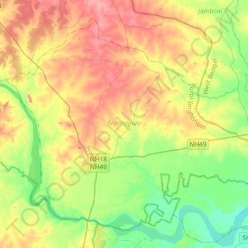
Name: Baharagora topographic map, elevation, terrain.
Location: Baharagora, Purbi Singhbhum, Jharkhand, 832101, India (22.21102 86.62492 22.42067 86.89057)
Average elevation: 253 ft
Minimum elevation: 108 ft
Maximum elevation: 436 ft
Other topographic maps
Click on a map to view its topography, its elevation and its terrain.
Baharagora
India > Jharkhand > Baharagora
Baharagora is located at 22°17′N 86°43′E / 22.28°N 86.72°E / 22.28; 86.72. It has an average elevation of 79 m (259 ft). The Subarnarekha River flows along its adjoining areas (approx at a distance of 7 km [4.3 mi]).
Average elevation: 249 ft