
Thank you for supporting this site ❤️
Make a donation
Make a donation
Gear up for your next adventure:
As an Amazon Associate, this site earns from qualifying purchases at no extra cost to you.
Sferracavallo topographic map
Click on the map to display elevation.
Thank you for supporting this site ❤️
Make a donation
Make a donation
Gear up for your next adventure:
As an Amazon Associate, this site earns from qualifying purchases at no extra cost to you.
About this map
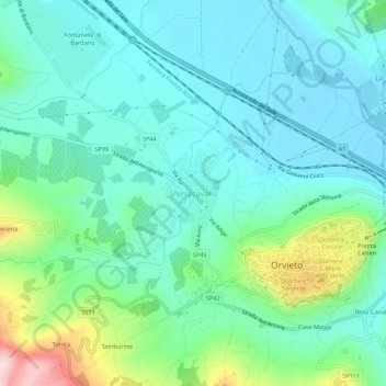
Name: Sferracavallo topographic map, elevation, terrain.
Location: Sferracavallo, Orvieto, Terni, Umbria, 05018, Italia (42.70603 12.07562 42.74603 12.11562)
Average elevation: 620 ft
Minimum elevation: 371 ft
Maximum elevation: 1,476 ft
Thank you for supporting this site ❤️
Make a donation
Make a donation
Gear up for your next adventure:
As an Amazon Associate, this site earns from qualifying purchases at no extra cost to you.