Geolocate

Bartonville topographic map

Click on the map to display elevation.

About this map

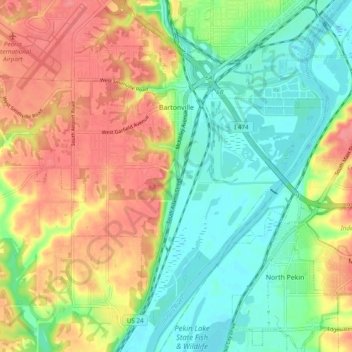
Name: Bartonville topographic map, elevation, terrain.

Location: Bartonville, Peoria County, Illinois, 61607, United States (40.60417 -89.70820 40.66788 -89.61190)

Average elevation: 541 ft

Minimum elevation: 433 ft

Maximum elevation: 673 ft

Peoria County trails, hiking, mountain biking, running and outdoor activities

Other topographic maps

Click on a map to view its topography, its elevation and its terrain.

Maxwell

United States > Illinois > Peoria County

Average elevation: 679 ft

Detweiller Park

United States > Illinois > Peoria County > Peoria

Average elevation: 610 ft

Mossville

United States > Illinois > Peoria County

Average elevation: 512 ft

Gear up for your next adventure:

🧷Carabiner Set - Durable clips for gear attachment
🧥Waterproof Jacket for Hiking - Breathable and rugged rain jacket for outdoor excursions
🛶Inflatable Kayak - Portable kayak for rivers, lakes, and expeditions
🔊Portable Camp Speaker - Music and alerts at camp
📷Action Camera - Capture your outdoor adventures in HD

As an Amazon Associate, this site earns from qualifying purchases at no extra cost to you.