Geolocate

Arnside topographic map

Click on the map to display elevation.

About this map

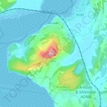
Name: Arnside topographic map, elevation, terrain.

Location: Arnside, South Lakeland, Cumbria, England, United Kingdom (54.17416 -2.87860 54.20523 -2.80904)

Average elevation: 75 ft

Minimum elevation: -3 ft

Maximum elevation: 541 ft

Gear up for your next adventure:

📖Nature Tracking Books - Learn to track wildlife and terrain
📷Action Camera - Capture your outdoor adventures in HD
🦶Carbon Trekking Poles - Reduce knee impact on steep descents with ultra-light poles
🥾Hiking Shoes - Durable and comfortable shoes for trail hiking
🔌USB Car Charger - Car charger for on‑the‑go power needs

As an Amazon Associate, this site earns from qualifying purchases at no extra cost to you.